Lehi Loop Shared Use Path Phase II Feasibility Study, Mesa AZ
project OVERVIEW
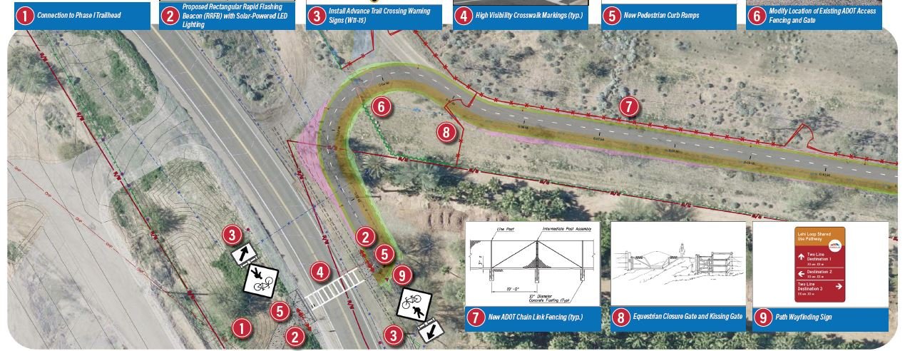
Y2K Engineering recently developed the feasibility study and 15% design concept plans for the Lehi Loop Shared Use Path Phase II project, located along SR 202L Red Mountain between McDowell Road and Val Vista Road in Mesa, Arizona. The project will provide a new off-street option for pedestrians, bicyclists, and equestrian users. This project involved coordination with ADOT and the Salt River Pima-Maricopa Indian Community (SRP-MIC). This trail is intended to provide access to the Lehi Crossing Monument, a place of significance within The Church of Jesus Christ of Latter-day Saints history. The future pathway will be located predominately within ADOT freeway right-of-way, but physically separated by over 150 feet from the motor vehicle travel lanes. The evaluation considered existing grade, drainage, connectivity, safety barriers, ADOT maintenance access, wayfinding, and two new pedestrian crossings. Based on coordination with the stakeholder team, a preferred alignment was selected that minimized impact to ADOT operations, existing utilities, and need for earthwork. The study also evaluated fencing, gates, and latches that would provide access to users of all abilities while restricting wildlife, due to the wild horses and cattle that exist in the area, particularly north of SR 202L. The study recommended a series of gates that were ADA accessible, able for bikes to easily cross, and a larger swing gate that can be opened while on horseback. The deliverables of the project included a Feasibility Study, 15% design concept plans, and a conceptual cost estimate.
services provided
Active Transportation Planning
Trails and Greenways
Project Assessment Report

